Beyond The Backyard with Gerrit Roelof
A Walk Around Hebo Mountain
Gerrit Checks Out Historic Hebo Mountain
(HEBO, Ore) — I recently found myself with a day off, looking for a new destination to explore. I chose Hebo. This is a small town along Highway 101 between Lincoln City and Pacific City. It takes about an hour and 15 minutes to get there from Salem, by following Highway 22 west ,make sure to veer right just before the casino, as Hwy 22 and 18 split from each other. I’ve spent a fair amount of time here in the past, chasing salmon and steelhead on the Nestucca. But this time I brought my hiking boots.
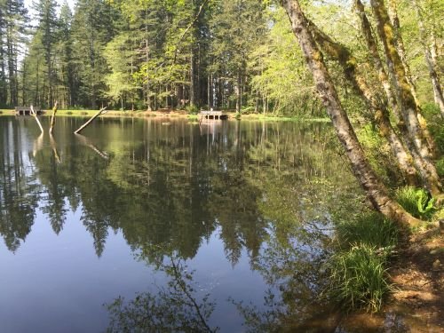
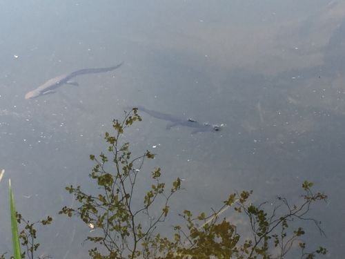
My first stop was the Hebo Ranger Station. The staff was extremely helpful, with current condition information and maps if you need them. From there I drove up the 14 road, also called Hebo Mountain Road, just behind the Ranger Station. The climb lasted about 4.5 miles until I found the open gate to Hebo Lake on my right. The lake sits at 1650’ elevation, and is a cozy 3 acres in size. This lake gets stocked every year, and on the day of my visit, the fish were jumping as if they suffered from a severe case of spring fever. There is also a very healthy population of salamanders, which would be fun for the kids to hunt for.
The lake is very accessible, with 5 fishing docks and a .5 mile trail around its circumference. I am told that due to its small size, the fishing is hot in the spring after the stocking truck visits, and slows throughout the summer as the small lakes fish population is depleted. During my trip there was only one person fishing, and none of the dozen primitive tent camping sites were occupied.
For the hikers, the Pioneer-Indian Trail starts at the lake on an 8 mile route through the coast range forest. This journey takes you first to Hebo Mountain. This was an active military post at one time, housing the 689th Radar Squadron. Although it’s a perfect location for radar, it also experiences some of the most severe weather in the coast range. The military tried three times in five years to build a radome capable of protecting their sensitive equipment. The first two version were defeated by mother nature in less than 12 months. The third version only lived three years before succumbing to the elements. I imagine they chose a different way to monitor their equipment after that. Another indication of the extreme weather was the large corrugated pipes which were used as passageways between the buildings, to protect people from the flying rocks during winter storms!
With or without the radomes, the installation was active for roughly 20 years, with a small community living on this tall mountain. I noted cement along the side of the road near the top, evidence of either a long forgotten sidewalk, or perhaps a viaduct of some kind. But anyhow, back to the hiking. If you start at Hebo Lake, it’s roughly 5 miles to the top of the mountain, revealing 360 degree views from mountaintop meadows. This mountain is the 2nd highest in the coast range, dwarfed only by Mary’s Peak to the south. It feels like you could almost throw a rock down to Pacific City below. If 5 miles is more than you were hoping for, you can cheat like I did. About halfway up, the trail crosses the 14 Road (Hebo Mountain Road). There is a small pullout here, and then an easy 2.5 mile walk up to the summit. If the full 8 miles is more your speed, you can pass through these high meadows, and end your day at South Lake.
After you’re done with the hike, jump back in the car and drive to the old military installation site. There is a collection of weather and transmission towers still present there. You can also find some interesting informational kiosks and plaques with photos and stories about the community that once resided on this lofty destination. Please stay on the trails in this area, as there are some endangered butterfly populations which have made these meadows their home. On my way home I wondered about what living up there must have been like in the 60’s and 70’s, and started making a list of my next potential destinations.