36 Pit Fire Crosses South Fork of Clackamas River; 45 Percent Contained
On Sunday, the priority is to halt the progression of the fire to the west.
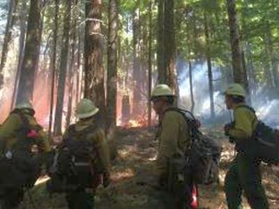
(ESTACADA, Ore. ) — On Saturday as predicted, the 36 Pit Fire area was impacted with unfavorable firefighting weather.
Firefighters were faced with a major wind event of high winds from the east gusting to 40 mph. Dry relative humidity and temperatures in the mid-80s also accompanied the winds.
The fire lines were tested and the majority of lines held, a testament to the work done by firefighters during the past week.
However, the fire did cross to the west of the South Fork of the Clackamas River and has bumped up against the 45 Road/Hillockburn Road. Firefighters worked throughout last night building fire line,holding the fire, and watching for spots.
On Sunday, the priority is to halt the progression of the fire to the west.
The fire was initially attacked by the US Forest Service, and Oregon Department of Forestry. Estacada Fire District 69 was dispatched to prepare defensible spaces around structures and to assist Clackamas County Sheriff Deputies with evacuations.
The Washington Incident Management Team 2 was called in to assume command of the fire on Monday, September 15 at 6:00 p.m.
A Unified Command led by Incident Commander Russ Lane of the Oregon Department of Forestry, Bruce Holloway of the Washington Incident Management Team 2, and Scott Magers of the Oregon State Fire Marshal Blue Team was established 9/15.
Governor Kitzhaber declared a conflagration September 15 thereby allowing for the mobilization of structural protection task forces from throughout the State of Oregon. Due to the decreased threat to structures, the Oregon Fire Marshal Blue Team was demobilized at the end of the day shift 9/18/14. Oregon Department of Forestry Incident Commander Russ Lane transferred command to Ross Holloway of the Oregon Department of Forestry due to a personal commitment.
Most of the fire growth occurred on Sunday, 9/14 and Monday, 9/15 burning on both sides of Highway 224. The fire is located mainly within the Mt. Hood National Forest along the stretch of the Clackamas River roughly between the South Fork of the Clackamas River at the northwest and Carter Bridge Campground at the southeast. A northwest portion of the fire also affects Bureau of Land Management and private lands.
Fire suppression priorities are to hold the progression of the fire at the west and north flanks of the fire protecting property and natural resources. Hazards to firefighters include steep rocky terrain, rolling material, fire weakened trees, and powerlines. The public is urged to drive safely while firefighters work to suppress the 36 Pit Fire.
The Clackamas County Sheriff's Office is coordinating the following evacuation notices:
Level 3 (LEAVE NOW)
- 29511 and 29513 Hillockburn Road
Level 2 (Be set to leave at a moment's notice)
- 27950 and 27980 Hillockburn Road
- 28059 and 28106 Hillockburn Road
- All homes on the east side of Habelt Road to Skinner Road
- All homes on Skinner Road east of Habelt Road
- All homes on the east side of Kinzy Road north of Skinner Road through 27845 Kinzy Rd.
- All homes on Brief Road
Level 1 (Be ready)
- All homes on Hillockburn Road west of Habelt Road to the Dodge Church
- All homes on Pederson Road
Source: US Forest Service/Clackamas County